
Excerpt from Map of Washington DC Showing 2 Contraband Maps
Having ancestors who lived in a contraband camp in Memphis during the Civil War has created enormous interest in the history of the "Contrabands" themselves--the refugee slaves who freed themselves during that time of conflict.
My ancestor Mary Paralee Young was the sister of my gr. gr. grandmother Amanda Young Barr. During a raid into northern Mississippi, in 1864 Union soldiers entered the small town of Ripley. Able bodied black men joined the Union forces readily, obtatining much longed for freedom. Later that same night, those remaning slaves who could travel, left also following the route taken by Union soldiers.
My ancestor Paralee Young described what happened the night they left the estate of Tandy Young of Tippah County Mississippi:

Deposition of Mary Parlalee Young Taken from Pension File Application of Amanda Young Barr, widow of Berry Young, Civil War soldier.
Upon arrival in Saulsbury Tennessee, she and dozens of others were sent on to Memphis where they would live out the war in a contraband camp, called President's Island.
Mary Paralee Young Tells of Being Taken to President's Island Contraband Camp
Paralee Young and her children lived on President's Island till 1866 when she later settled in Memphis, where she would spend the remainder of her life.
After reading about her being taken to President's Island, I wanted to know more---where was this place, this contraband camp, and where there other such places? I have learned how throughout the south---such facilities arose near the Union lines and wherever there was an encampment of Union soldiers with newly recruited black men as part of the line.
After asking questions for a long time, I eventually learned that this Memphis site is now a peninsula that extends into the Mississippi River directly from downtown Memphis. But I have yet to find any maps that reflect the area, so I decided to use Google Maps to find my own map and to get an image of the area.

A View of President's Island using Google
I realize that today the island is used mostly for industrial purposes, however, I learned that until the 1960s, people still lived on President's Island, and that there was even a small schoolhouse on the island as well. The schoolhouse has since been moved and the community left the island in the 1960s. Searches for any remnants of this historically black settlment leave me baffled--as there appears to be nothing found online--neither map nor photo, nor evidence that this was once a Civil War era Contraband Camp.
The few images of President's Island speak only to the current use as an industrial park and nothing of this once being a home for runaway slaves, can be found in current maps and images.
I did find an aerial view of President's Island as it is today. This is from the President's Island Industrial Association website.

The Association's site did present a brief history of the island. However no images have surfaced yet of this being a settlement for many years after the war ended.
Earlier this year, a friend and genealogy research colleague share with me a map of Hampton Virginia. This map reflected the community of Hampton roads during the years after the Civil War. I became profoundly interested, when I examined the map and spotted a very large contraband camp that occupied much of what is today downtown Hampton.
The camp eventually became an area referred to as Slabtown.

Image of Slabtown that grew from the Grand Contraband Camp in Hampton VA

Hampton Neighborhood Today Once Part of Slabton--Grand Contraband Camp
On another map I was looking at a Washington DC map showing a route that President Lincoln took to go from the White House to the Soldier's Home. On the map, his route was outlined, and two places caught my eye---they both indicated that they were Contraband Camps. Their location surprised me as they were not far from Logan Circle in Washington DC.
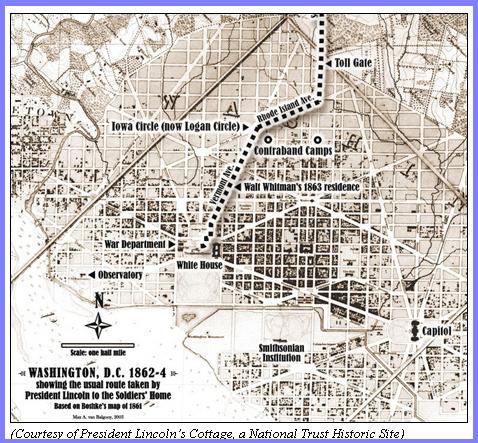
Image of Washington DC Map Showing Two Camps off Logan Circle

Location of Camp Today Using Google Map

12th and O Street NW Washington DC Looking West- Site of Old Contraband Camp

12th and O Street NW, Washington DC Looking East -Site of Old Contraband Camp
These locations are important, and need to be known. This history of the camps, the people in those camps represent part of the untold story of the Contrabands of War America's Forgotten Freedom Seekers.
They and their history deserve to be replaced on America's historical landscape once again.
There are other sites still to be uncovered and stories still to be told. I am currently interested in documenting the sites of contraband camps that I have learned of in Arkansas from Pine Bluff, to Ft. Smith, and even westward to Ft. Gibson in Indian Territory.
As one whose history is connected also with the Civil War Contrabands, I look towards finding more evidence of these courageous men and women and moving them from being mere footnotes to history, but true players in the winning of their own freedom.
2 comments:
Do you have any idea how many Contraband camps there were?
It is believed that there are well over 100 sites that are known to have existed. I look at records from the Freedmen's Bureau and notice letters sent by military officers to a higher ranking order, making references to "negroes flocking to the camp every day." Such descriptions were of contrabands and often the "camps" were mere makeshift places where they were able to take refuge and gain their freedom. Some such encampments never had names but they were still treated as contrabands, and their freedom was gained.
Post a Comment